learning how to identify productive areas on a lake map can turn a random fishing trip into a planned search. A good map shows where fish are likely to feed, rest, and move. Anglers across the United States use these tools on lakes, reservoirs, and rivers before launching their boats.
After years of studying lake maps, one lesson stands out: fish rarely sit in random places. They follow underwater roads, edges, cover, and changes in depth. When you understand what those features mean, a simple map becomes a guide to finding active fish.
Understand what makes an area productive on a lake map
Before learning how to identify productive areas on a lake map, understand what makes a location attractive to fish. Productive areas usually provide food, shelter, oxygen, and safe travel routes. Fish often gather where several of these needs meet.
A map does not show fish directly. Instead, it reveals the underwater conditions that influence fish behavior. The goal is to find places where fish have a reason to be there.
- ✦ Food sources
Areas near baitfish, insects, vegetation, and current breaks often attract feeding fish.
- ✦ Cover and protection
Brush piles, rocks, weeds, and timber give fish places to hide and ambush prey.
- ✦ Travel routes
Channels, creek beds, and contour changes act like underwater highways.
Why map study improves fishing decisions
Many anglers waste time covering empty water. A lake map helps narrow the search before the first cast. This saves fuel, time, and effort while increasing the chance of finding active fish.
Learn how to read contour lines and depth changes
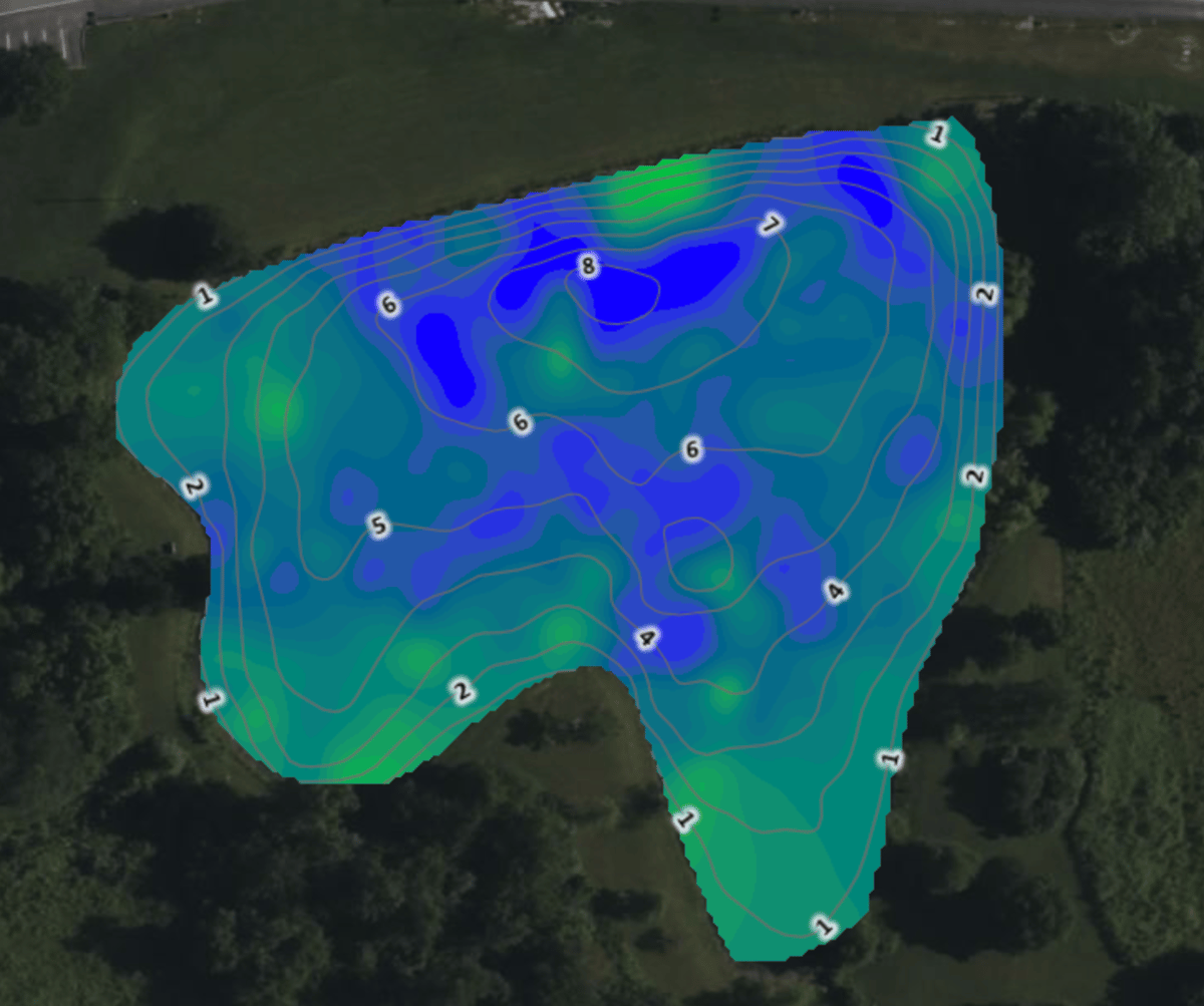
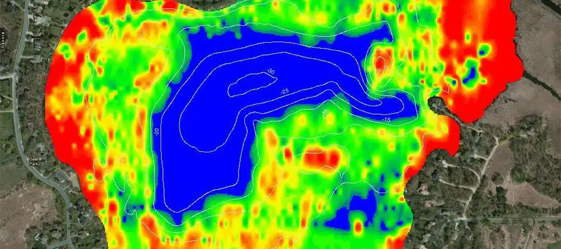
Contour lines are one of the most important tools when learning how to identify productive areas on a lake map. Each line represents a change in water depth. Close lines show steep drops, while wider spaces show gradual slopes.
Fish often use depth changes because they create natural feeding zones. A bass may move from deep water to a shallow flat through a nearby drop-off. Walleye and other species may follow similar edges during seasonal movements.

- ✦ Points
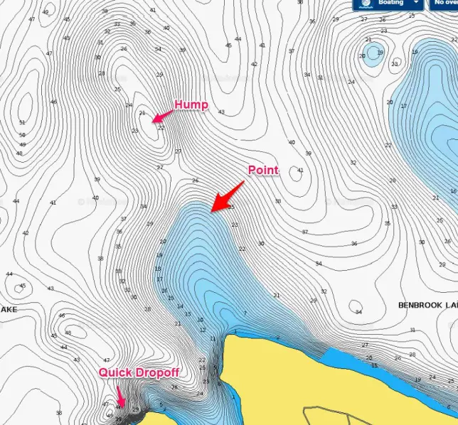
Underwater points extend into deeper water and often create feeding areas where fish can trap prey.
- ✦ Drop-offs
Sharp depth changes give fish quick access to shallow and deep zones.
- ✦ Humps
Submerged hills can hold fish when surrounded by deeper water.
Use contour spacing as a fishing clue
A map with tight contour lines shows areas worth checking because steep edges often concentrate fish. When several features meet, such as a point near a channel, the location becomes even more interesting.
Find underwater structure that attracts fish
Structure is one of the biggest clues when deciding how to identify productive areas on a lake map. Structure means physical features on the bottom, such as ridges, channels, rock piles, and submerged trees.
The best locations often combine structure with depth changes. A single feature can hold fish, but a feature connected to a travel route is usually more valuable.
- ✦ Creek channels
Old creek beds create paths fish may follow throughout the year.
- ✦ Submerged roads and foundations
Human-made features can provide hard edges and cover.
- ✦ Rock transitions
Changes from mud to rock can attract crawfish and baitfish.
Combine structure with fish behavior
The most useful map reading skill is connecting features with fish habits. For example, a rocky point near deep water may be valuable because fish can feed shallow and escape deep quickly.
Use vegetation, flats, and seasonal patterns together
Vegetation and shallow flats are important when learning how to identify productive areas on a lake map. These zones often produce oxygen, shelter, and food for many fish species.
Season changes also affect which map areas matter most. Fish may move shallow during spring, follow deep edges during summer, and transition between zones during fall.
- ✦ Spring fishing
Look near shallow spawning areas, protected coves, and warming flats.
- ✦ Summer fishing
Search deeper edges, channels, and areas with cooler water.
- ✦ Fall fishing
Focus on baitfish locations and migration routes.
Why vegetation maps can help
Vegetation maps add another layer of information. They help anglers find areas where fish can feed and hide, especially in lakes with large weed beds.
Create a map-based fishing plan before you launch
Knowing how to identify productive areas on a lake map is only useful when you apply the information. Mark possible spots, rank them by quality, and test them with electronics and careful fishing.
Many experienced anglers create a short list of locations instead of trying the whole lake. This approach helps them learn patterns and improve each trip.
- ✦ Mark possible hotspots
Save points with promising structure, depth changes, or habitat features.
- ✦ Confirm with electronics
Use sonar and GPS tools to check what exists below the boat.
- ✦ Keep fishing notes
Record depth, weather, season, and successful patterns.
Avoid relying on maps alone
A lake map is a starting tool, not a guarantee. Water levels, weather, fishing pressure, and seasonal changes can affect fish location.