Learning how to read a depth map for fishing can completely change the way you approach a lake, river, or reservoir. Instead of randomly casting, you can study the underwater landscape before you even launch your boat. A good map can reveal places where fish travel, feed, and hide.
After years of studying fishing maps and combining them with time on the water, one lesson stands out: fish rarely sit in random locations. They follow underwater highways, edges, cover, and changes in depth. A depth map helps you see those hidden features before your first cast.
What Is a Fishing Depth Map and Why Does It Matter?
A fishing depth map is a visual guide that shows the shape and depth of underwater terrain. Many anglers call these maps contour maps or bathymetric maps. They work like a topographic map, but instead of showing hills and valleys on land, they show underwater rises, slopes, and depressions.
Understanding how to read a depth map for fishing gives you a better idea of where fish may be located before you start searching. In the United States, many anglers use digital lake maps on fish finders, GPS units, and fishing apps to plan trips on lakes and reservoirs.
- ✦ Find hidden structure
Depth maps reveal underwater points, humps, channels, and ledges that are difficult to see from the surface.
- ✦ Plan fishing routes
Maps help anglers move between productive areas instead of spending hours covering empty water.
- ✦ Understand fish movement
Depth changes often create feeding zones and travel paths for many freshwater and saltwater species.
Depth Maps vs Fish Finders
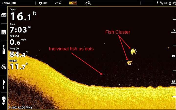
A depth map shows what the underwater terrain looks like, while a fish finder shows what is happening beneath your boat in real time. The best anglers use both tools together.
A map may show a steep drop-off, but sonar can confirm whether baitfish, vegetation, or game fish are currently using that area.
- ✦ Depth map advantage
It helps you prepare before reaching a location.
- ✦ Sonar advantage
It provides current information about fish and underwater conditions.
How to Understand Contour Lines on a Fishing Map
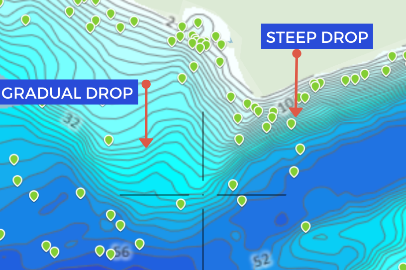
Contour lines are the foundation of learning how to read a depth map for fishing. Each line represents a specific depth level. Lines that are close together show a steep drop, while lines spread far apart show a gradual slope.
Fish often use contour changes because these areas provide movement routes, feeding opportunities, and protection. A sudden depth change can create an underwater edge where predators wait for prey.
- ✦ Tight contour lines
These indicate steep banks, drop-offs, and underwater cliffs that can attract fish.
- ✦ Wide contour spacing
These areas usually represent flats or gradual slopes where fish may feed.
- ✦ Closed contour circles
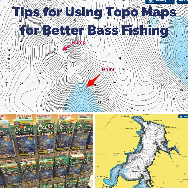
These often show underwater humps, islands, or deep holes.
Reading Depth Numbers
Depth numbers provide exact measurements that help you understand water zones. A bass angler may look for a 10-foot ledge near a 25-foot basin, while a saltwater angler may search for specific reef depths.
The right depth depends on species, season, water temperature, and local conditions.
- ✦ Compare nearby depths
Look for areas where shallow and deep water meet because these transition zones are often productive.
How to Find Fish-Holding Structures on a Depth Map
The main goal of learning how to read a depth map for fishing is finding places where fish are likely to spend time. Structure is any underwater feature that changes the normal bottom shape.
Experienced anglers focus on areas where depth, cover, and current combine. These locations often provide shelter and food sources.

- ✦ Points
Underwater points extend into deeper water and can act as feeding areas.
- ✦ Drop-offs
Sharp depth changes allow fish to move between shallow and deep water.
- ✦ Channels
Old river channels create natural travel routes, especially in reservoirs.
- ✦ Humps
Submerged hills can attract fish because they create isolated feeding zones.
Why Structure Attracts Fish
Structure gives fish advantages. Predators can hide near edges, while baitfish can find food and protection nearby.
A depth map does not guarantee fish will be present, but it helps you identify places worth checking first.
Using Depth Maps With Seasons and Fish Behavior
Knowing how to read a depth map for fishing becomes more powerful when you understand seasonal fish patterns. Fish move because of temperature, spawning cycles, food availability, and oxygen levels.
In spring, many species move toward shallow areas. During summer, fish often seek deeper, cooler water. In fall, they may follow baitfish along depth changes.
- ✦ Spring strategy
Look for shallow flats near deeper water where fish can transition easily.
- ✦ Summer strategy
Focus on deeper edges, channels, and shaded structure.
- ✦ Fall strategy
Search for areas where baitfish and predators move together.
How Modern Fishing Technology Improves Map Reading
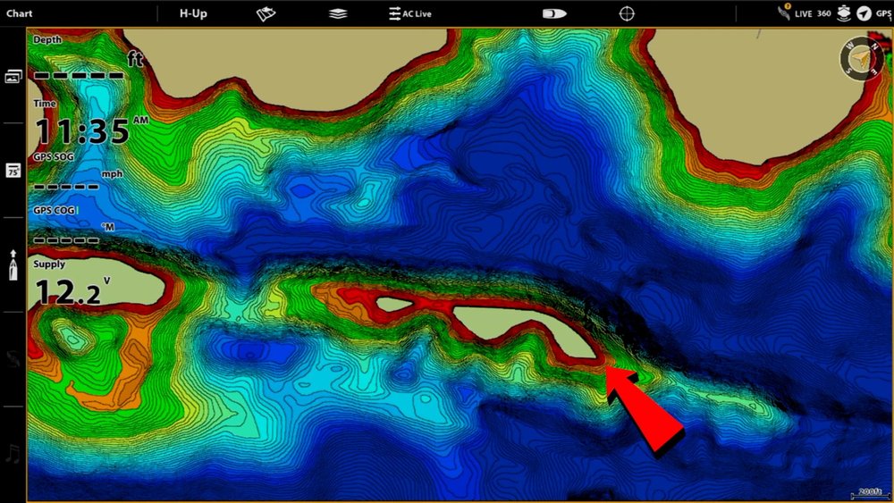
Modern electronics make it easier than ever to apply what you learn about how to read a depth map for fishing. Many GPS fish finders now include detailed mapping, satellite views, and custom depth data.
Anglers can mark productive areas as waypoints and return to them during future trips. This turns random fishing into a repeatable process.
- ✦ GPS waypoints
Save locations of productive structure and return to them quickly.
- ✦ Side imaging
Scan wider areas to locate cover and underwater objects.
- ✦ Digital mapping updates
New map data can provide more accurate underwater details.
Combining Maps With Real Water Experience
Maps are valuable tools, but they should support your observations. Water levels change, vegetation grows, and fish behavior shifts throughout the year.
The strongest anglers use maps as a starting point and confirm their decisions with conditions on the water.
Common Mistakes When Reading Fishing Depth Maps
Many beginners make the mistake of looking only at depth numbers. Depth matters, but the change between depths often matters more.
Another common mistake is assuming every marked structure holds fish. A location must also have food, suitable conditions, and the right timing.
- ✦ Ignoring transitions
Fish often use boundaries between shallow and deep water.
- ✦ Fishing only obvious spots
Popular locations may receive heavy pressure and require a different approach.
- ✦ Skipping local research
Local knowledge, reports, and seasonal patterns improve map interpretation.